


The James S. Griffith Collection of Mayo and Yoeme Pascola Masks
Who Are the Mayos?
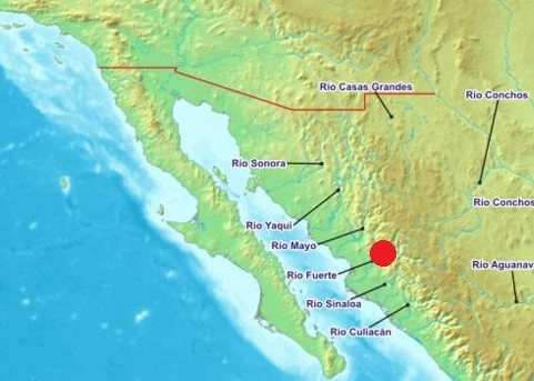
The Mayo Indians are an indigenous group living in the Río Mayo valley in Southern Sonora and the Río Fuerte valley in Northern Sinaloa.
View Zoomable Map of Río Yaqui, Río Mayo and Río Fuerte areas.
They are one of many groups of indigenous peoples who continue to live and maintain their culture in what today is Mexico—a diverse and multicultural country. The Mayo belong to the Cahita linguistic family and are so related to the Yoeme, the Ocoroni, and the Guasave Indian groups. Unfortunately, today, no members from the last two groups survive in northern Sinaloa, their original territory, or elsewhere in Northwest Mexico. Mayos maintain relationships with the Yoemem to the north and to the Guarijíos to the east (Sierra Madre) as well as with the mestizo Mexicans that live near or in their communities.
According to the group’s oral tradition, the word “Mayo” means “the people of the river bank” and refers to the Río Mayo in Sonora and Río Fuerte in Sinaloa. The Mayos call themselves Yoreme also, which means “he that respects the tradition.” Those who are not Yoreme are addressed as Yori, or “he that does not respect,” referring mostly to the mestizo Mexicans or other non-Indian peoples. Incidentally, Indians who deny their roots and community obligations are named Torocoyori or “he that betrays” or “he that denies the tradition” (Aguilar 1995; Crumrine 1990).
Mayo Indians are among the most numerous Indian groups in Mexico with more than 75,000 members distributed between more than 260 communities (Aguilar 1995). The traditional Mayo Indian territory runs from southern Sonora to northern Sinaloa and from the Gulf of California coast to the Sierra Madre Occidental; it covers almost 7,630 km2. Today, they share this territory with mestizo Mexicans. Mayo communities are located in the municipios (county) of Álamos, Navojoa, Etchojoa, and Huatabampo in Sonora and Los Mochis, El Fuerte, and Choix in Sinaloa. The most important ceremonial Mayo centers or communities are Júpare, Etchojoa, San Pedro, San Ignacio Cohuirimpo, Pueblo Viejo, Navojoa, Tesia, Camoa, Huatabampo, and Conicárit.
The climate in Mayo country varies from desert to sub-tropical. A rainy season falls between July through September, but rain averages 400 mm annually. The maximum temperature falls around 45°C (110°F) in the summer and a minimum of 10°C (52°F) in winter, with an average of 25°C (77°F) . The Río Mayo and the Río Fuerte are the major rivers of the area, although several minor perennial rivers exist in the region as well. The soils in the Mayo region are rich and of the chestnut type with adequate humus but inadequate moisture; when irrigated, these fields make suitable farming lands. Currently and historically, this area with its reliable water sources, such as the Río Mayo, forms one of the most productive farming areas in the country today. The vegetation consists of mesquite, cottonwood, torote, joso, oak, and several species of cactus, such as agave, cholla, and pitahaya. Javalina, deer, rabbit, hare, mice, bobcats, puma, jaguars, snakes and several species of birds, lizards, and insects complement the desert flora. Unfortunately, urbanization, loss of natural habitats, and overexploitation have brought most of the fauna to the brink of extinction (Aguilar 1995; Griffith 1967a).
The Mayo ceremonies and traditions reflect the region’s diversity of natural resources and geographical characteristics. Mayo dances mimic the movement of the animals in the wild, the hunt, and the relationship between nature and people (Aguilar 1995; Crumrine 1990).